

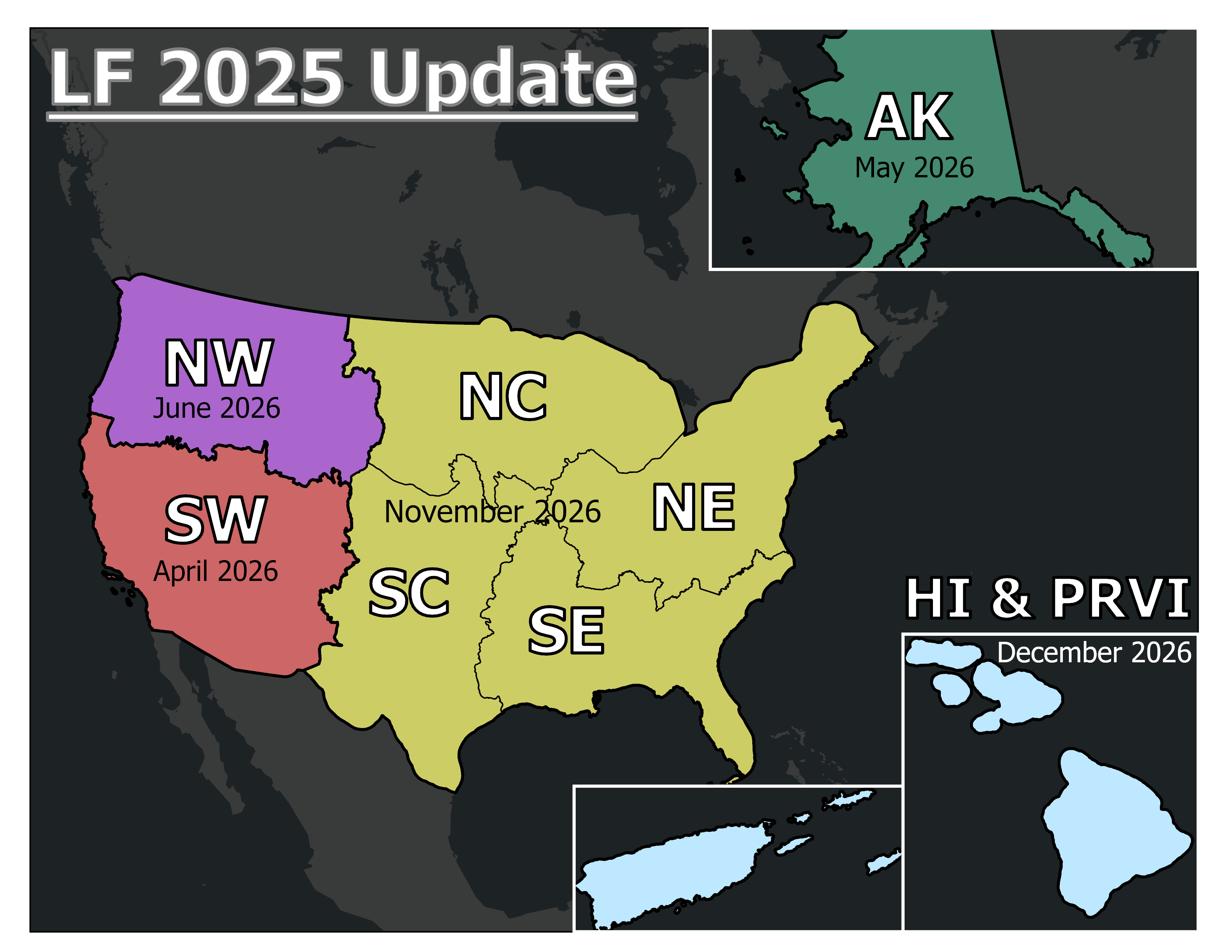
The LANDFIRE 2025 Update (LF 2025) product suite maintains LANDFIRE's ongoing goal to release annual updates that are current to the previous year. This means LF 2025 accounts for disturbances up through Fiscal Year 2025 and is being released in 2026. The releases are intended to provide critical, up-to-date information ahead of the fire season for areas of the United States prone to large devastating wildfires. New this year, LF 2025 begins with the Southwest (SW) GeoArea of the Conterminous United States (CONUS) release in the spring, then followed by Alaska (AK). After that, the Northwest (NW) GeoArea is released in early summer; LF 2025 will wrap up with the release of full CONUS extent and Hawaii (HI) and Puerto Rico and the US Virgin Islands (PRVI) in the fall.
In LF 2025, disturbance products continue to leverage agency-submitted data and analyst verification of multiple satellite change detection techniques. The vegetation products are updated using rulesets similar to LF 2022 Update (LF 2022) but only for 2025 disturbances since prior disturbances were brought current using machine learning and 2023 satellite imagery during the LF 2023 Update (LF 2023). The fuels products are updated for 10 years of disturbance using rulesets like in LF 2022, LF 2023, and LF 2024. In addition, vegetation and fuels products include updates in both burnable and non-burnable agricultural lands.
New and exciting this year:
- Improvements to the Fuel Characteristic and Classification System Fuelbeds (FCCS) product.
- Improved agricultural areas mapping by switching to using the latest Cropland Data Layer (CDL) for CONUS and HI.
- LANDFIRE is now using Harmonized Landsat Sentinel (HLS) data for the creation of Seasonal Fuels products, which will begin releasing in the spring.
- Improvements for Alaska mapping, including an updated disturbance footprint utilizing satellite change detection.
- An updated Public LF Reference Database (LFRDB) is scheduled to release in the fall. This will be the first update for the LFRDB since the LF 2016 Remap effort!
| THEME | PRODUCT NAME | ABBREVIATION |
|---|---|---|
| Disturbance | Limited Disturbance | LDist |
| Preliminary Disturbance | PDist | |
| 2025 Annual Disturbance | Dist25 | |
| Fuel Characteristic Classification System Fuelbeds | FCCS | |
| Fuel | Fuel Disturbance | FDist |
| 13 Anderson Fire Behavior Fuel Models | FBFM13 | |
| 40 Scott and Burgan Fire Behavior Fuel Models | FBFM40 | |
| Forest Canopy Bulk Density | CBD | |
| Forest Canopy Base Height | CBH | |
| Forest Canopy Cover | CC | |
| Forest Canopy Height | CH | |
| Canadian Forest Fire Danger Rating System | CFFDRS | |
| Fuel Vegetation Cover | FVC | |
| Fuel Vegetation Height | FVH | |
| Fuel Vegetation Type | FVT | |
| Fuel Rulesets Database | FRDB | |
| Reference Disturbance and Treatment Polygons (Events) LF Reference Database | Raw Events | - |
| Model Ready Events | - | |
| LFRDB | ||
| Vegetation | Existing Vegetation Type | EVT |
| Existing Vegetation Cover | EVC | |
| Existing Vegetation Height | EVH | |
| Succession Classes | SClass | |
| Vegetation Departure | VDep | |
| Vegetation Condition Class | VCC |
Conterminous United States (CONUS) GeoAreas will release throughout 2026, beginning with the Southwest (SW) GeoArea in April. The full product suite for Alaska (AK) will release in May. Hawaii (HI) and Puerto Rico and the US Virgin Islands (PRVI) will conclude the year, releasing in December.
| Month in Calendar Year 2026 | Products and/or Extents |
|---|---|
| January | LDist CONUS, AK, HI, PRVI |
| April | SW GeoArea |
| May | AK |
| June | NW GeoArea |
| September | Dist25 CONUS/AK, LF Disturbance and Treatment Polygons GDB (all extents) |
| November | Remaining GeoAreas for CONUS - SC, SE, NC, NE |
| December | HI and PRVI, FRDB (all extents) |