

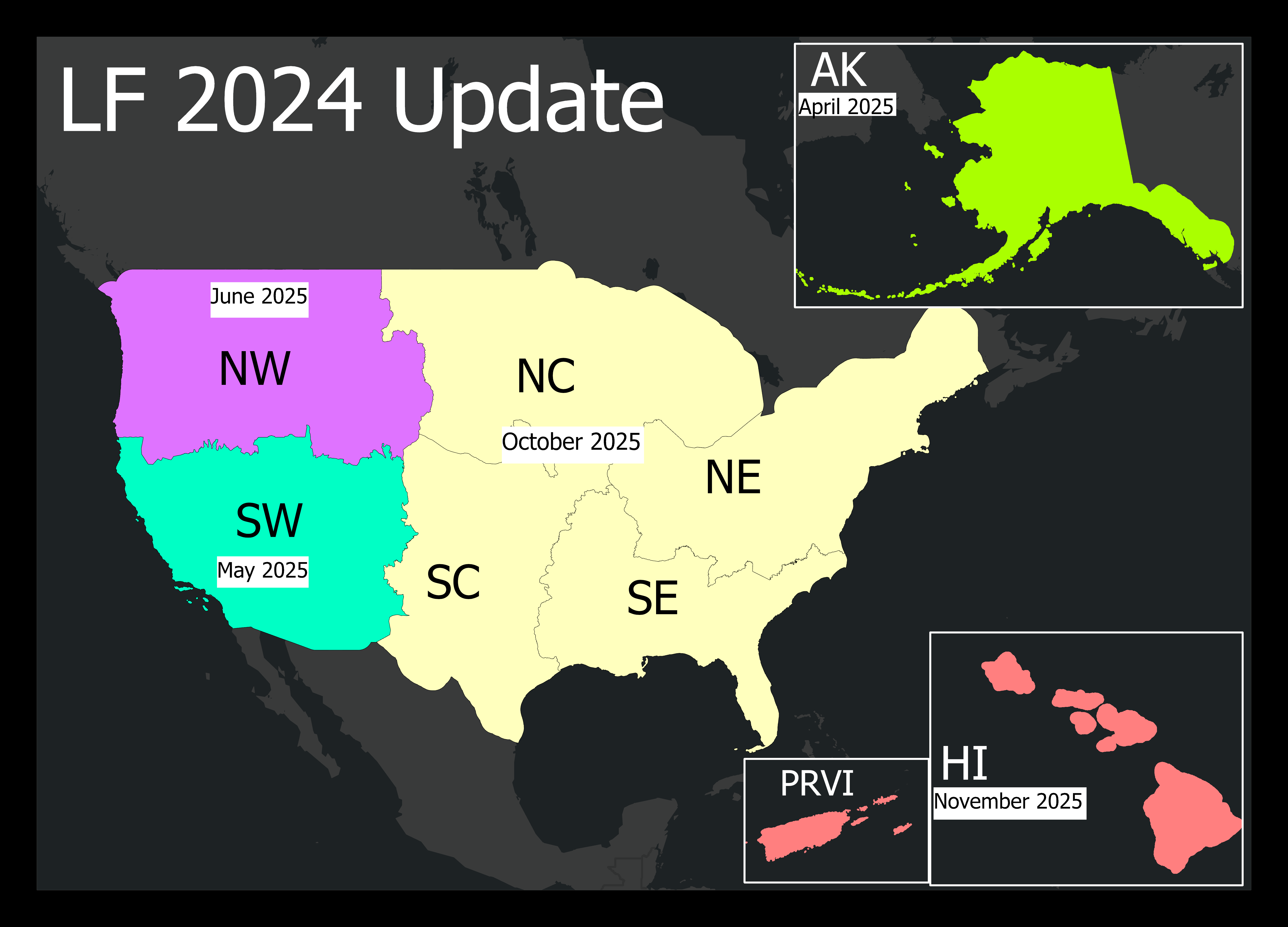
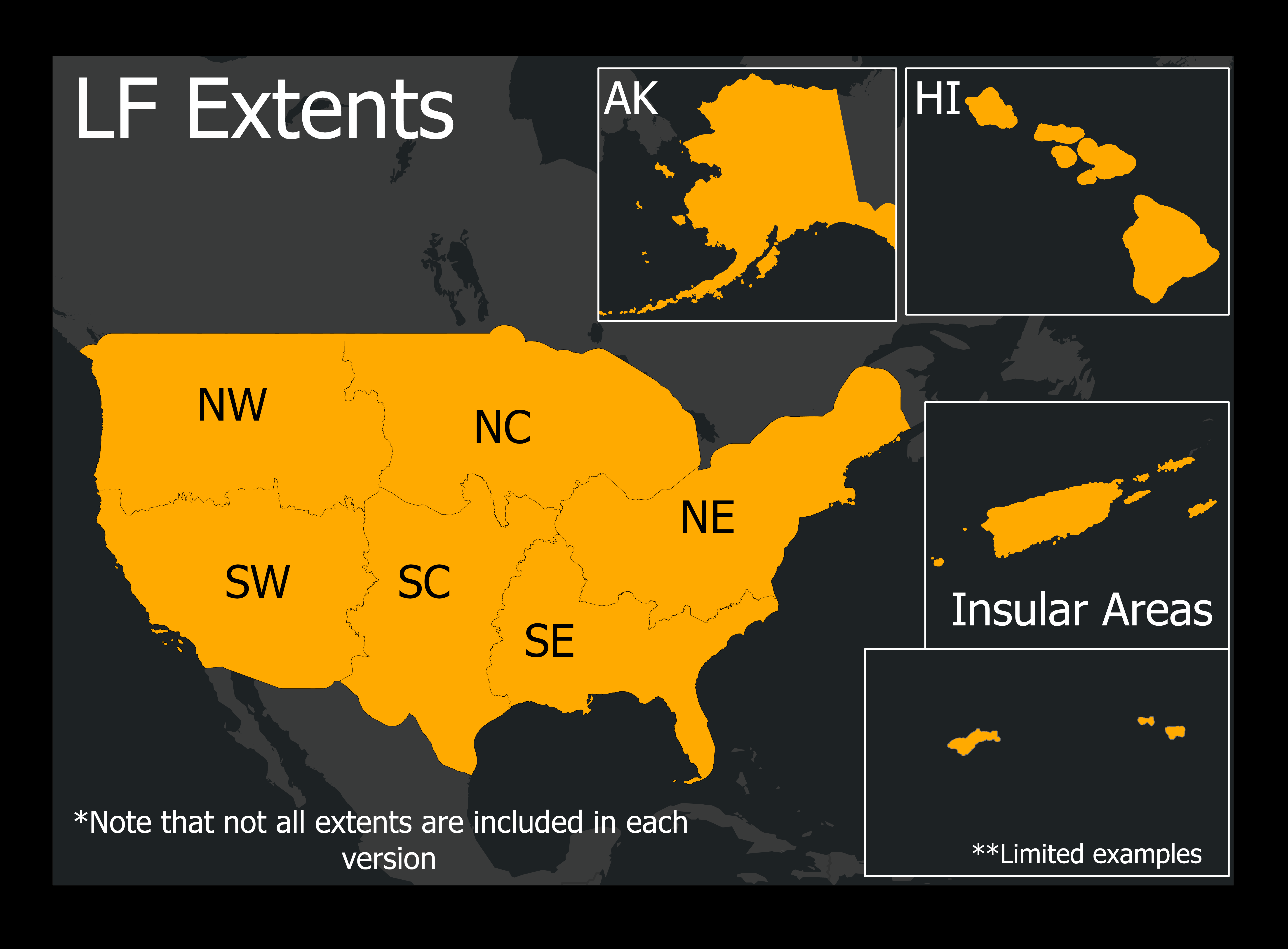
The LANDFIRE 2024 Update (LF 2024) product suite maintains LANDFIRE's ongoing goal to release annual updates every year that are current to the previous year. This means LF 2024 accounts for disturbances up through Fiscal Year 2024 and is being released in 2025. The releases are intended to provide critical, up-to-date information ahead of the fire season for areas of the United States prone to large devastating wildfires. LF 2024 begins with the Alaska release in the spring, followed by the Southwest (SW) and Northwest (NW) GeoAreas of the Conterminous United States (CONUS) in the summer, and wraps up with the release of full CONUS extent and Hawaii and Puerto Rico and the US Virgin Islands in the fall.
In LF 2024 disturbance products continue to leverage agency-submitted data and analyst verification of multiple satellite change detection techniques. The vegetation products are updated using rulesets similar to LF 2020 Update (LF 2020) and LF 2022 Update (LF 2022) but only for 2024 disturbances since prior disturbances were brought current using machine learning and 2023 satellite imagery during the LF 2023 Update (LF 2023). The fuels products are updated for 10 years of disturbance using rulesets similar to LF 2020, LF 2022, and LF 2023. In addition, vegetation and fuels products include updates in both burnable and non-burnable agricultural lands.
Improvements Featured in the LF 2024 Update
- The Annual Disturbance attribute table (legend) has been re-worked to modernize it and make improvements. The crosswalk between past and current disturbance years can be downloaded here (automatically downloads .xlsx). This impacts all 3 Annual Disturbance products that LANDFIRE delivers throughout the year: Limited, Preliminary, and Final. To learn more, read Reconstructing the Annual Disturbance Legend: A Record of Change.
- Alaska Preliminary and Final Annual Disturbance products will now use imagery to estimate severity (High, Moderate, Low, and No severity) similar to CONUS. Severity assignments from fire programs such as MTBS, RAVG, and BARC will continue to be used and prioritized. Additionally, the Final Annual Disturbance product for Alaska includes satellite-mapped disturbances independent of the LF Events Geodatabase or fire program data. This marks the first time since LF 2016 Remap where remote sensing-based change is provided for Alaska.
- Hurricane Helene disturbance data was incorporated into LF 2024 Preliminary Disturbance Data (August 2025). The data is derived from HiForm data. LANDFIRE’s mapping approach for Helene was unique to all previous years because satellite-captured disturbances are categorized as "Unknown causality." In this instance, we were able to leverage the HiForm data and compare it with our composite imagery to create the final map and assign severity based on LANDFIRE protocols, with a "Weather" causality.
Here is an example that demonstrates severity assignment improvements for AK in LF 2024:
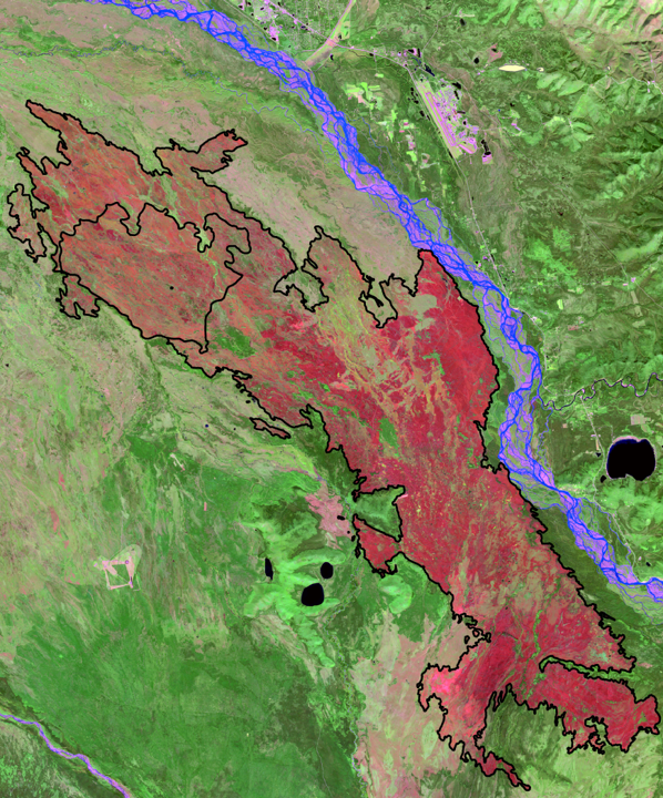
This burn scar represents two 2024 fire scars captured in the LF 2024 Update for AK.
The small perimeter is the fire scar from the Clear Fire.
The larger perimeter is from the McDonald Fire.
Both fires burned from June to September 2024.
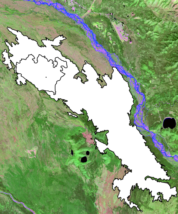
In previous years, these fire scars in AK Disturbance would look like this. All white within the perimeters indicating Low severity. In the past, if a severity wasn’t indicated in the agency submitted data attributes, the default severity assignment was “No severity”. Then LANDFIRE Fuel Disturbance (FDist) rules would re-reassign these areas to Low severity, so that there was at least representation of severity in some capacity versus none.
However, in those cases, burns experiencing High and Moderate severity were grossly underestimated. Additionally, areas that received no fire damage were incorrectly assigned as a Low severity.
In LF 2024, LANDFIRE wanted to improve this.
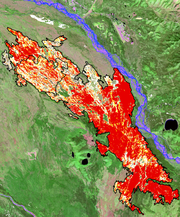
Imagery is used to estimate severity in AK for LF 2024.
The fire severity assignments derived from pre- and post-fire images include 4 classes: Non-burned, Low, Moderate, and High.
In this graphic the clear areas inside the perimeters are non-burned, followed by white (Low severity), yellow (Moderate severity), and red (High severity).
| THEME | PRODUCT NAME | ABBREVIATION |
|---|---|---|
| Disturbance | Limited Disturbance | LDist |
| Preliminary Disturbance | PDist | |
| 2024 Annual Disturbance | Dist24 | |
| Historical Disturbance | HDist | |
| Fuel | Fuel Disturbance | FDist |
| 13 Anderson Fire Behavior Fuel Models | FBFM13 | |
| 40 Scott and Burgan Fire Behavior Fuel Models | FBFM40 | |
| Forest Canopy Bulk Density | CBD | |
| Forest Canopy Base Height | CBH | |
| Forest Canopy Cover | CC | |
| Forest Canopy Height | CH | |
| Canadian Forest Fire Danger Rating System | CFFDRS | |
| Fuel Vegetation Cover | FVC | |
| Fuel Vegetation Height | FVH | |
| Fuel Vegetation Type | FVT | |
| Fuel Rulesets Database | FRDB | |
| Reference LF Public Events Geodatabase | Raw Events | - |
| Model Ready Events | - | |
| Vegetation | Existing Vegetation Type | EVT |
| Existing Vegetation Cover | EVC | |
| Existing Vegetation Height | EVH | |
| Succession Classes | SClass | |
| Vegetation Departure | VDep | |
| Vegetation Condition Class | VCC |
The first full product suite release for the LF 2024 Update will be April 2025 for Alaska (AK). Then Conterminous United States (CONUS) GeoAreas will release throughout 2025, beginning with the Southwest (SW) GeoArea in May. Hawaii (HI) and Puerto Rico and the US Virgin Islands (PRVI) will conclude the year, releasing in November.
| Month in Calendar Year 2025 | Products and/or Extents |
|---|---|
| January | LDist CONUS, AK, HI, PRVI |
| April | AK |
| May | SW GeoArea |
| June | NW GeoArea |
| August | Dist24 CONUS/AK, LF Public Events GDB (all extents) |
| October | Remaining GeoAreas for CONUS - SC, SE, NC, NE |
| *December | HI and PRVI, FRDB (all extents) |
* This schedule has been updated as of November 2025