Latest News
 LANDFIRE (LF) data products are important
for programmatic planning, analysis, and reporting for fire and natural resource management. Over the last 18 years, the number of LF data products and applications, including web-based applications, has increased.
LANDFIRE (LF) data products are important
for programmatic planning, analysis, and reporting for fire and natural resource management. Over the last 18 years, the number of LF data products and applications, including web-based applications, has increased.
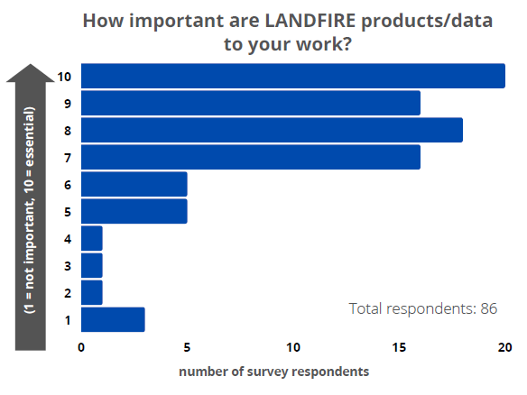
To continue to meet the growing demand for applicable data, LF partners at The Nature Conservancy (TNC) developed a questionnaire to explore and understand the interaction of the user community with LANDFIRE Program products. The program received 117 responses and appreciates the time taken to provide feedback to the program.
LF 2021 LF Questionnaire Results 
Below are the responses to user suggestions that the Program is already addressing in some way. In the future, LF will respond to other suggestions and feedback.
User Suggestions:
Many Agriculture Types Need to Be Burnable
The LANDFIRE Program has moved towards making most federal agriculture lands burnable in the fuels layer for LANDFIRE (LF) 2020. These adjustments are not final. More may need to be done to ensure that fuel attributes are appropriately applied to the various types and ownerships of agriculture lands.
Need More Frequent Updates
The LANDFIRE Program is incrementally transitioning to an annual delivery including disturbances from the previous year. The version currently in production (LF 2020) to be delivered in June/July of 2022 (1 year following the previous delivery) will reduce data latency to 18 months. The program is hoping to deliver a LF 2022 version in the Summer of 2023 that includes as many disturbances from 2021 and 2022 as possible.Ecological Systems (EVT and BpS) to NVC Group Crosswalk
A crosswalk between NatureServe Ecological Systems (ES) and National Vegetation Classification Group (NVCG) is available and can be provided by request. This crosswalk will be reviewed by NatureServe soon. Some Existing Vegetation Type (EVT) categories cannot be cross walked to NVCG because they do not represent natural vegetation, e.g., Urban, Agriculture, Ruderal, etc.
BpS Descriptions need to be more accessible
A separate website is available (www.landfirereview.org) where Biophysical Settings (BpS) descriptions can be identified and downloaded by name or by specific searchable characteristics, such as dominant species.
Need More Information About Deviations from Reference Data
The LANDFIRE Vegetation Departure (VDep) spatial layer represents deviations in structure/primary composition from reference data based on LANDFIRE BpS model information and spatial data and the LANDFIRE Succession Class (SClass) layer. It is important to note that LANDFIRE VDep/Vegetation Condition Class (VCC) is relevant for very large regions. However, these layers were not produced in the LF 2019 Limited (LF 2019L) version so there is no updated VDep or VCC since LF 2016. The VDep and VCC layers will be created in LF 2020 for CONUS and delivered in the Autumn of 2022.
Need Data in Canada and Mexico
LANDFIRE 2016 vegetation and fuels spatial layers in Alaska are now delivered 90km into Canada. We are delivering a generalized version of vegetation and fuels layers along a 90km buffer along the remaining international borders with Canada and Mexico for LF 2020.
Use ecoregion boundaries to reduce seamlines
Beginning with LF 2016, the LANDFIRE Program used Omernik Level III and IV ecoregions as the framework for vegetation mapping instead of National Land Cover Database (NLCD) map zones and will continue this approach in the future.
Continuous value raster layers would be helpful
Beginning with LF 2016 LANDFIRE Existing Vegetation Height and Existing Vegetation Cover are delivered as continuous values, e.g., 1% for vegetation cover in all life-forms and 0.1m for herb/shrub heights and 1m for tree heights.
Categorize continuous MFRI and connections to FEIS would be helpful
We prefer that users categorize Mean Fire Return Interval (MFRI) values locally using GIS functionality because different organizations, and applications may require different categories. Fire Effects Information System (FEIS) staff have included connections to LANDFIRE BpS in the information they make available to users.
A Simpler and Flexible Data Download Interface would help users
LANDFIRE recently developed and released a new, modern user interface for exploring and downloading LANDFIRE spatial products. A series of training videos is available on the LANDFIRE YouTube channel.
Feedback Summary: